How To Read a Hazard Rose Forecast:
Resources: https://utahavalanchecenter.org/forecast/tutorial
“The bottom line: the danger rose is a visual tool that allows us to see the big picture of what goes on in the mountains”
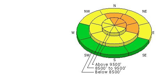
Understanding the Danger Rose Location Sections:
“The danger rose is used to indicate what the danger ratings are in different locations. The locations vary depending on which direction they face on a compass (north, south, east or west) and by elevation.”
-Utah Avalanche Center

What Does This Mean?
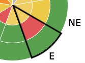
Each pie section (left to right rose petal) represents the location based on the direction of facing slopes.
In this example, this pie slice represents the danger level on an East facing slope

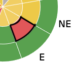
Each pie sub-section (top down rose petal) represents the elevation of the directional facing slope.
In this example, this pie sub-section slice represents the danger level on an East facing slope with elevation of 8000 – 9500 FT

Understanding the Danger Rose Color Legend:
Danger Ratings contain 5 Levels depicted via a color legend.

What Does This Mean?
This means that the darker the color gets on the hazard rose, the more dangerous the relative risk of an avalanche is. Disclosure: Do not traverse terrain in areas and dates where the forecast shows a hazard rose with sections falling in the red and black colors.

What To Do In Case of Emergency
Backcountry Emergency Incident Response Tips

Mountain Dispatch Numbers:
Salt Lake and Park City – Alta Central (801-742-2033)
Canyons Resort/PCMR Dispatch (435 -615-1911)
Snowbasin Resort Dispatch (801-620-1017)
Powder Mountain Dispatch (801-745-3772 x 123).
Sundance Dispatch (801-223-4150)
For more information on Avalanche Awareness & Forecasting
visit the UtahAvalancheCenter.org